FAIRFIELD COUNTY – A three-day severe weather event affected South Carolina this past week, with Thursday being the worst of the weather for Blythewood and Fairfield County.
Temperatures reaching the 90s Wednesday afternoon and dew points in the upper-60s and low-70s created the perfect environment for storms to develop.
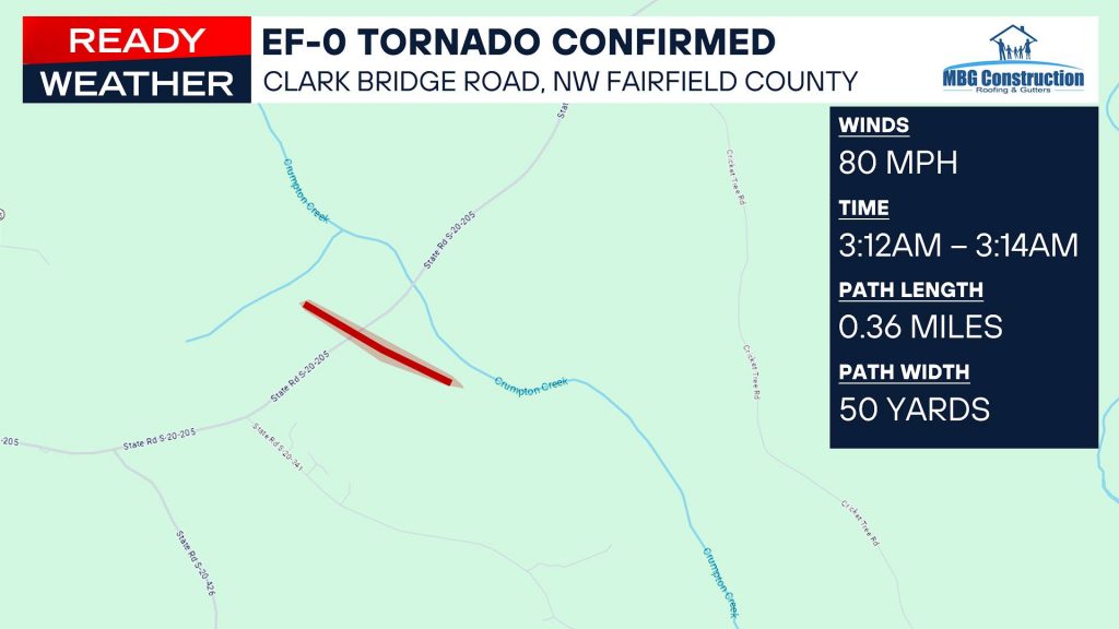
Residents in Ridgeway, Blythewood, Winnsboro and western Fairfield County were awakened about 3:16 a.m. on Thursday morning by tornado warning alerts on their smart phones and watches. The National Weather Service later determined that a few minutes earlier, at 3:12 a.m., an EF-O tornado had caused extensive tree and roof damage near Monticello on Clark Bridge Road in Fairfield County. The tornado, with winds peaking at 80 miles per hour, had traveled along a 50-foot wide path for .36 miles.
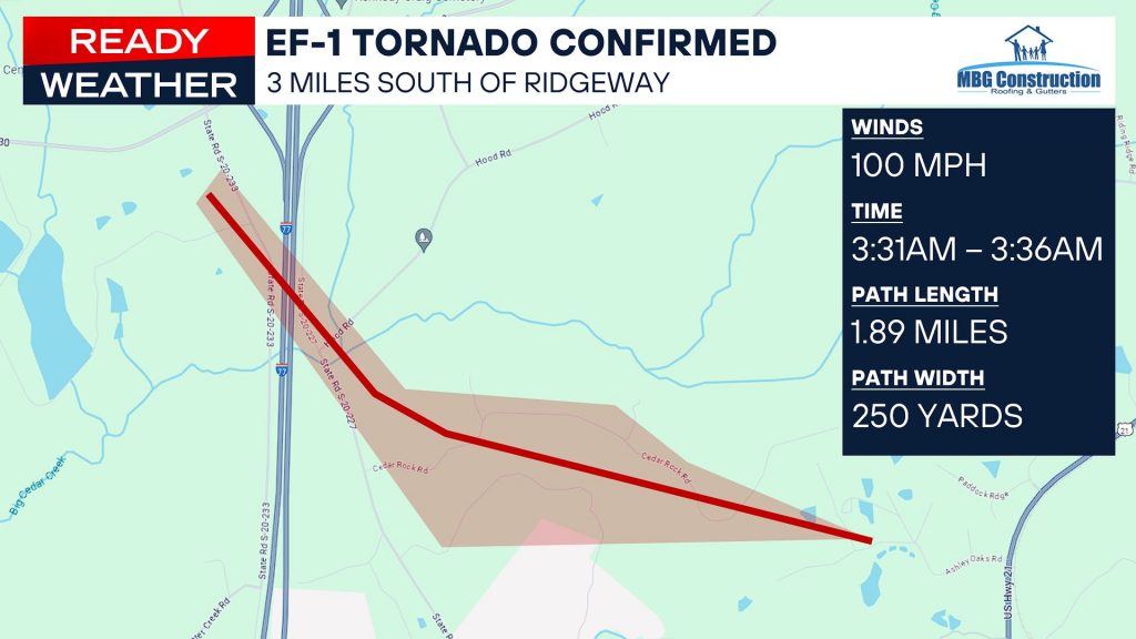
Another, larger tornado in Fairfield County, determined to be an EF-1 tornado, occurred at 3:31 a.m. and ended five minutes later at 3:36 a.m., traveled over a 250-yard wide path for 1.89 miles, along Cedar Rock Road – between Hood Road and The Farm at Ridgeway – with winds peaking at 100 miles per hour.
The risky weather in Blythewood, Ridgeway, Winnsboro and western Fairfield County had started at about 3 p.m. on Wednesday when the National Weather Service issued a severe thunderstorm watch as storms started to develop in the Upstate due to the heat and humidity. These storms ended up being large hail producers with hail ranging from ping pong ball size (~1.50 inches) to baseball size (~2.75 inches) in parts of the Upstate and Western North Carolina.
Storms from the Upstate passed through Blythewood and Fairfield County between 6 p.m. – 7 p.m. Wednesday evening, with plenty of available storm energy heading into Thursday morning.

A tornado watch was issued for the Upstate around 11:15 p.m., Wednesday night, extending into the western Midlands by 1:30 a.m. Thursday morning.
By Thursday morning, the line of storms had advanced east to show signs of rotation over Whitmire in Union County around 3:05 a.m., aiming for an area north of Ridgeway into the Western Midlands by 2:15 a.m.
At 3:12 a.m., the EF-O tornado hit near Monticello on Clark Bridge Road in western Fairfield County.
By 3:16 a.m., the tornado warning was issued for parts of Fairfield, Kershaw, and Richland Counties, including Blythewood, Ridgeway, Winnsboro, Elgin, and Camden.
By 3:31 a.m., signs of rotation were showing over Rion aiming for the Farm at Ridgeway.
The possibility of tornadoes was not the only concern during this time. The line of storms also prompted several severe thunderstorm warnings issued as well as the threat of 70 miles per hour winds from Rock Hill to Orangeburg.
The tornado warning expired at 3:45 a.m., Thursday morning, as the line of storms continued to advance east, slowly losing steam as it entered an environment less conducive for severe weather.
It’s important to always keep in mind that severe weather can come suddenly without a watch or a warning.
The National Weather Service issued another severe thunderstorm watch around 1 p.m. Friday afternoon, but Blythewood and Fairfield County dodged it.